|

light-version available
GPS
- GIS for
your PPC - GPS
What's it?
- Full-/Lightversion - GPS
- Why SingulArch-Pocket? - Design
- Safety - Functiones
- Bad Weather - Postprocessing
- Desktop-/Pocketversion - Hard-/Software
- How To Order - Download
- FAQ
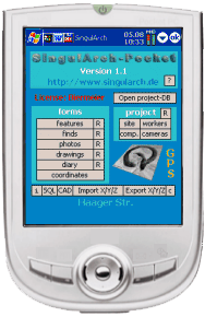
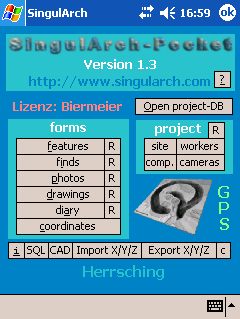
What
Is SingulArch-Pocket?
-
SingulArch pocket is an application for PPCs.
- It was designed for the collection of all kinds of data at archaeological
excavations. It can be used by geologists, biologists and other fieldworkers as
well as for any other purpose of collecting data and coordinates.
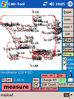
- SingulArch-Pocket contains a CAD-Tool, which is able to interpret GPS-data.
You can display bitmaps and your vectordata as well.
- Since version 1.3 data fom external devices (e.g. totalstations) can be
recieved and sent to (control e.g. your Geodimeter-totalstation via SingulArch (ask for other
models)).
Full-
Or Light-Version?
-
The light-version is for users, who want to work with the CAD-tool, coordinates
and GPS only. Main parts of the database functionality are disabled in the
light-version (also the possibility of connecting other serial devices, like
totalstations).
- Users of the full-version get a CD-Rom with SingulArch-Sync also, so they are
able to synchronize Pocket- and Desktop-projects. All forms of the database are
enabled.
SingulArch-Pocket
und GPS
-
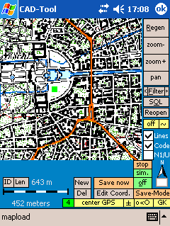
Since version 1.1 SingulArch is able to interpret GPS-data.
- Since version 1.2 (geo-)referenced bitmaps can be displayed in the CAD-Tool.
- Since vesion 1.42 there is a 'DGPS'-like tool: Two PPCs can be connected via
WLAN. The 'server' is placed on a known coordinate and sends its aberration to a
second PPC. With this tool SingulArch-Pocket is perhaps the most accurate
GPS-solution for PPCs on the market.
- There are tools helping you to create your own maps.
- When you leave the borders of a map in GPS-mode, SingulArch-Pocket will try to
load a fitting map on its own.
- GPS-coordinates can be mapped and saved either as decimal coordinates (WGS84),
UTM (without zone) or as Gauss-Krueger-coordinates.
- import and export of Top50-map-overlays is possible. Thus SingulArch-Pocket
can be used as simple navigation system (see pictures below).
Im-
and export of Top50-Overlays; displaying maps in the CAD-tool;
transformations and several other tools
-
GPS-data is drawn in the CAD-Tool and can be saved by button-click or in a free
definable interval.
- GPS-coordinates are stored in the same table as your coordinates from e.g.
your totalstation.
- SingulArch pocket and e.g. the Yakumo delta 300 GPS (260.- €) are a complete
system for carrying out surveys of any kind.
- Together with the GPS-function SingulArch-Pocket also is interesting for
geologists, biologists and everybody else who wants to collect data "on the
way".
Do
I really need SingulArch-Pocket?
-
Fieldwork causes hours of boring indoor-work and costs a lot of time and much
money, if the lists, descriptions etc. must be put into databases, excel-sheets
or text documents later on.
- SingulArch-Pocket was designed as a database, which lets you collect all kinds
of data from archaeological excavations or other projects in one program and at once, not later on!
About
The Design Of SingulArch-Pocket
-
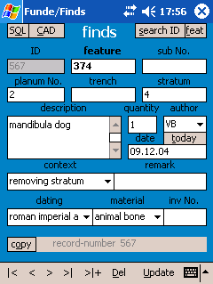
SingulArch-Pocket is a Visual-Basic-program (frontend), which lets you open
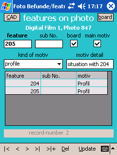
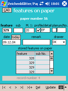
special project backend CDB-Databases (Pocket ACCESS)
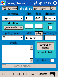
- the datasets are developed relationally (E.G. kind of camera > photo >
features on photo)
Is
My Data Safe?
-
users of the licensed version have to enter an password (there is an administrator- and user-password). The
administrator may change, add and delete data records. Users are allowed to
change and add but not delete.
- users, who have no password may use SingulArch-Pocket as a project-viewer only.
- your data is quite well protected from abuse this way.
- saving your DB on memory cards once in a while offers you a maximum of
security against loss of data.
Important
Functions
-
you can filter at will in all forms. The SQL-filter-statements can be stored and
used again at any time.
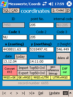
- different kinds of coordinate data can be imported into the DB.
- you can also use SingulArch-Pocket, if you do not possess the (German only) Desktop version
of SingulArch.
- create reports (textfiles) out of your data and e.g. send it via infrared to a
visitor whom you want to give detailed information.
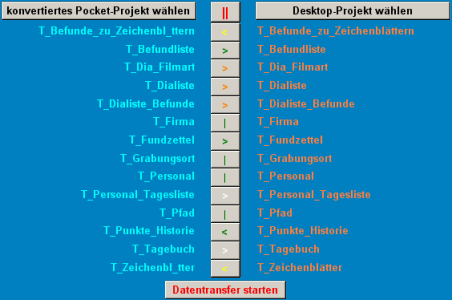
- you can convert desktop projects from SingulArch into pocket-projects and vice
versa (see picture below).
- numerous drop down fields, based on textfiles, help you to enter your data
quickly.
- the work with SingulArch-Pocket does not require a long training period.
- in the CAD-tool you can filter, change, edit, convert and add coordinates via
the graphic surface.
- coordinates can be written as points with text (code) into a DXF-file which
you can open with almost any CAD-program
- a SQL monitor is integrated. You can open every pocket ACCESS DB with
SingulArch-Pocket.
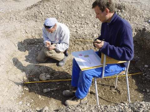
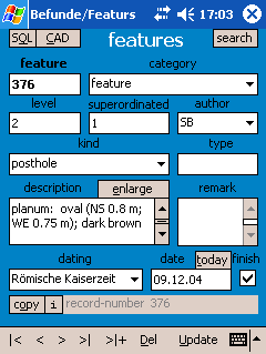
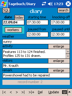
SingulArch-Pocket: documentation
of features and finds
Bad
Weather?
-
pack your PPC into waterproof clip-bags. Your equipment will be protected this
way.
Postprocessing
-
no more running back and forth beetween notebook/desktop and e.g. finds: with
SingulArch-Pocket you have all the data with you at any time.
- easy controlling of finds, photos, papers etc.
synchronisation-tool between
pocket- and desktop-projects
Where
Is The Desktop-Version Better?
-
the MS ACCESS desktop-version has better report functions. Nevertheless
SingulArch-Pocket lets you create reports as textfiles.
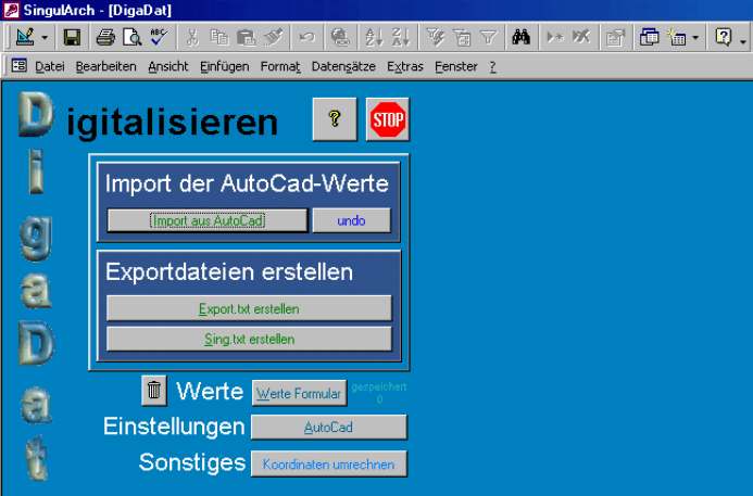
- Creating scripts for AutoCad is the biggest difference between the two
versions: with SingulArch-Pocket you can just create AutoCad-scripts or
DXF-files which draw
points and codes as text. The desktop-version creates complicated scripts -
depending on the codes of the coordinates - with levellings, outlines of
features, profiles etc.: Just look at some of the AutoCad-screenshots
in the desktop-versions mainpage.
Where
Is The Pocket-Version Better?
-
SingulArch-Pocket has with its CAD-Tool an integrated graphical interface which
helps you to handle your coordinates.
- SingulArch-Pocket has GPS
- You can have SingulArch-Pocket always with you. PPCs' accumulators should last
the whole day.
What
Do I Need?
-
a Pocket PC (starting from 200. - €; with integrated GPS-antenna about 260.-
€)
- If you have got a PC 2002 you have to install service release I, otherwise
there is an error message concerning Active X.
- the EVB (Embedded Visual Basic Runtime; Download
it from Microsoft for free)
is necessary and no longer included in the standard distribution of PPCs.
What
Is The Difference Between The Demo and The Licensed Version?
-
you may not save with the demo-version. SingulArch-Pocket is like a
project-viewer.
- you also cannot save GPS-data but you are able to import Top50-overlays, so
you can use the demo-version as a simple navigation system.
Where
Can I Get the Licensed Version And How Much Is It?
-
there is an order
form
for German Customers with the actual list of prices.
- mail me if you come from outside of Germany and are interested in the licensed
version.
Feedbackl
-
I'm interested in your opinion. Let me know about errors, wrong translations
etc. (e.g. via the feedback-form).
Download
Demo SingulArch-Pocket 1.42!
Your Feedback
helps me to improve the software
General
characteristic:
you
cannot store data in the demo. For testing purpose there is an excavation of a
late La Tène-settlement (Erding.cdb) attached. You have to copy this file
into the folder \My documents \ to be able to load it.
GPS will work in the demo-version but you may not save coordinates.
what you need Pocket PC 2003 or Pocket PC 2002 with service release I
installed.
Version: 1.41
Legal: a commercial use of the demo version is not permitted!
Note: I am not responsible for possible damage to your computers or
file systems in connection with the installation and work with SingulArch
pocket.
The
Files
Files
(choose between ARM, SH3 and MIPS):
ARM.zip
(7,5
MB) - SH3.zip
(3,6
MB) - MIPS.zip
(4,4
MB)
EVB:
perhaps
you will also need the Embedded Visual Basic Runtime. Download
it from Microsoft for free.
Helpfiles: The helpfile
is included in the demo-version. The German helpfile for the desktop-version
(anleitung.zip)
gives detailed information about the forms and e.g. coding of coordinates.
New Projekt-DB: If you are already using Desktop-Projects of Version
6.2 you should replace the empty-project.cdb in your PPC (folder Programs\SingulArch-Pocket)
with this file: empty-project.cdb
(the
field Anzahl in T_Fundzettel is now a textfield and no longer an integer
number).
Project: The file Eching.zip (1
MB) contains the database of an excavation that was carried out 2005.
Prehestoric and carolingian Settlements with about 700 features were found in
Eching, Landkreis Freising.
FAQ - troubleshooting
Run Singular-Pocket and other EVB programs under Windows
Mobile 5.0 (WM5)
CDB-MDB-Conversion under WM5
In this workaround I
describe a way how you can run Embedded Visula Basic programs (EVB) on your
WM5-Device. Although it worked without any problems on my Fujitsu Siemens
N560 you will have to try this workaround on your own risk.
1. Make sure that you have installed ActiveSync 4.x on your Desktop
(ActiveSync-Versions 5.x or newer were not tested)
2. Install the EVB Runtime for WM5 on your mobile device: http://download.microsoft.com/download/e/6/7/e67b873f-7d9f-4ee0-9fde-364218fcfa95/msvbppc.armv4.cab
3. If ActiveSync doesn't work at all,
you may have to change the settings of your firewall (permissions for
WCESSCOM.EXE and WCESMGR.EXE). ZoneAlarm has probably to be deactivated
whenever you want to use ActiveSync...
4. Install ADOCE on your mobile device: http://www.nsbasic.com/pub/ce/6/installers/ADOCE.WM5.exe
5. Delete the following entry of your Desktop-registry: HKEY_LOCAL_MACHINE \ SOFTWARE \ Microsoft \ Windows CE services \ SpecialDefaults \ PocketPC04 \ services \ Synchronization \ Objects \ ~MicrosoftTable
6. Change the value of the registry-entry HKEY_LOCAL_MACHINE \ for Security \ Policies \ Policies \ 0000 1001
from 2 to 1. Most simply with the small program Rapi Securtity tester.
Copy the EXE file to your PPC and start it. Select the option “Full ACCESS”.
From now on EVB programs should run on your device and the conversion between CDB- and
MDB-files should function as well. Please give me a feedback whether
my workaround was useful for you.
ActiveX - Error In Connection With Pocket
PC 2002
Install Service Release I.
Eroror: Missing EVB (Embedded Visual Basic Runtime)
Download it for free: http://www.microsoft.com/windowsmobile/resources/downloads/developer/evb.mspx
GPS Doesn't Work?
Check your settings in gps.txt (com-port, com-port-settings). If
everything is correct and it still doesn't work, try a soft-reset. Sometimes
GPS needs up to five minutes to start working.
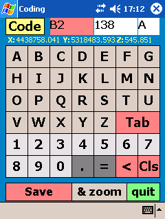
Coding Coordinates
How do I have
to code? How do I get lines?
Coding of coordinates is the same than in the desktop-version of
SingulArch. A coordinate has three differnet codes.
Code1 defines the type of coordinate, Code2 is the (feature)-number,
which you can filter in the CAD-tool very easily (must be an integer number), Code3
is an additional, optional letter.
All codes will be drawn as points, except coordinates with this Code1:
B0,...,B9
C0,...,C9
P0,...,P9
PP,GG
All coordinates with identical coding (all 3 Codes the same) will be
drawn as lines; e.g. all coordinates with Code1 = PP, Code2 = 1 (, Code 3 =
A) will be drawn as a line.
Something special about Code1 = N1 und NU. Within the CAD-Tool
their height can be.drawn as text.
You will find more informations about coding in the german instructions
to the desktop-version.
Demo-Version: World-map vanishes, when GPS
starts
Choose the angular coordinate-system when you start the CAD-Tool the
next time, because the world-map is saved as WGS-file. Choose the WGS-Option
in GPS-mode (button on the lower right side), before you load the map.
Other Problems
Give
me Feedback.
I cannot solve problems that I don't know about.
last update:
29.06.07
|


